Mapping places mentioned in the 1795 Louisiana Slave Conspiracy Pointe Coupée Trial Documents
last updated June 29, 2020
This document describes the process we used to identify the geographic locations of places named within the historical documents of the 1791 and 1795 Louisiana Slave Conspiracies in Pointe Coupée.
Associating geographic coordinates, specified as longitude and latitude, with places named within the Louisiana Slave Conspiracy documents allows us to map their location, thus providing geographic context to the locations both within Pointe Coupee and in the wider scope of colonial Louisiana. These geographic data also allow us to consider the spatial distribution of these locations and the people associated with them. For example, we will be able to address questions like: What was the geographic extent of the conspiracy? How tightly clustered where the involved estates?What was the relative density per estate of enslaved persons allegedly involved in the conspiracy? A more advanced research question would involve combining the geospatial data of known locations with social network analysis of the historical texts to estimate the locations of unknown named places.
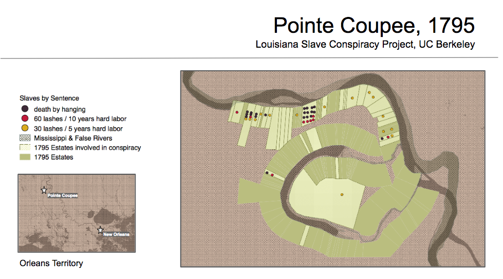
The majority of these places were large agricultural estates within the settlement of Pointe Coupee, ranging in size from approximately 62 to 8500 acres with a median of 346 acres, or locations within these estates such as cabins, storehouses or swamps. Other named places in Pointe Coupee include the fort and church, as well as more indeterminent locations such as roads or places along a road, along the river, or somewhere within the vast swamp which ran between the estates located along the southern banks of the Missisipi River and the northern section of the False River. The approximate locations of these places, as estimated with the methods discussed in this paper, are shown on the map below.

Determining the geographic locations of places mentioned in the historical documents is challenging for a number of reasons. First, we have thus far been unable to locate historical maps for Pointe Coupee from the 1790s that provide enough local geographic detail to resolve locations of places within the settlement. For example, below is an image of the Map of the Course of The Mississippi from the Missouri. Collot, George Henri Victor ; Tardieu, P.F. 1796, the only map from the 1790s that we could find that portrays Pointe Coupee with any detail.
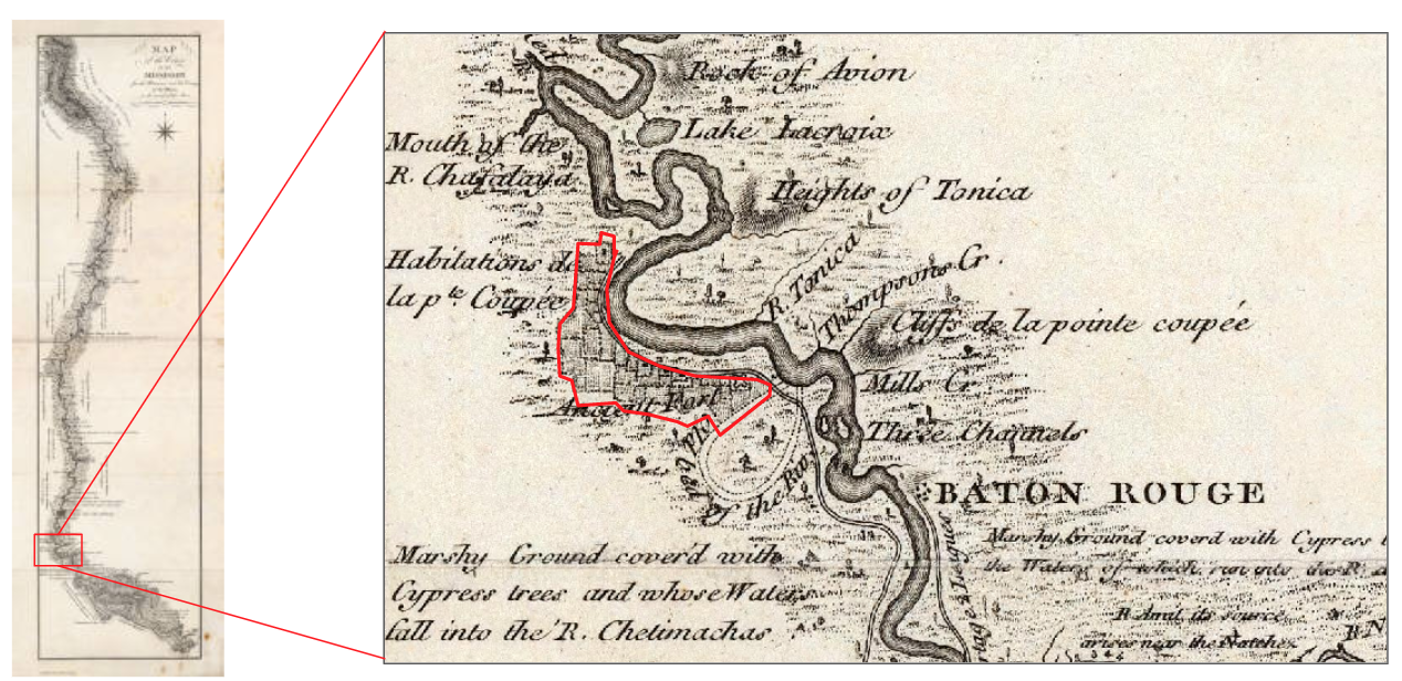
This map identifies the footprint of Pointe Coupee along the Mississippi River, and the Fort of Pointe Coupee Poste but does not contain any other locational information. Moreover, the level of local positional accuracy is likely low given the way in which the False River is depicted symbolically as a loop (labelled “old bed of the river”) rather than with geographic detail.
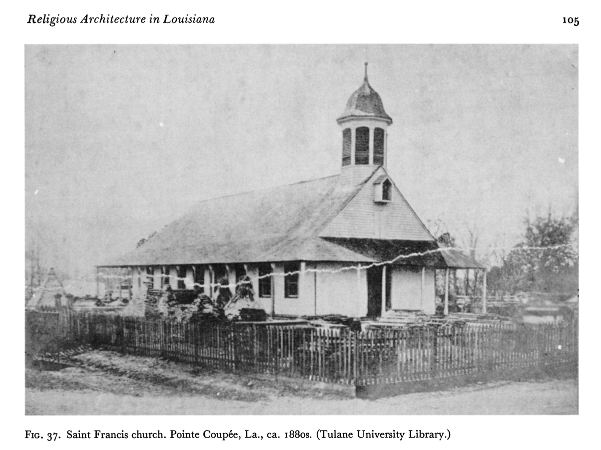
Another challenge to identifying the location of local places within Pointe Coupee is that few structures remain from that period. Most structures were located along the Mississippi River which was the main transportation route of the time. These include the Fort of Pointe Coupee and the St Francis Church, shown below, the latter of which figured prominently in the Pointe Coupee 1795 conspiracy.
Colonial Fort of Pointe Coupee, 1744

Second St. Francis Church of Pointe Coupee, 1760 - 1890.
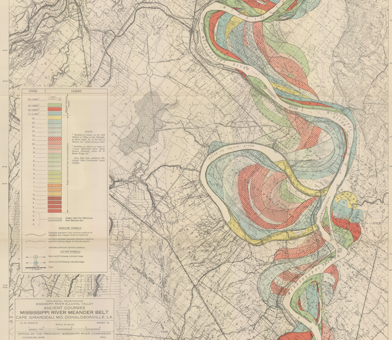
These structures and others along the river where inundated by flooding and eventually devastated by the changing course of the Mississippi River, whose fluctuations are beautifully depicted in the map Ancient Courses of the Mississippi Meander Belt, sheet 14, 1944, Mississippi River Commission, Harold Fisk, cartographer.
Yet another challenge is that while some maps from the 1700 and 1880s do exist, they are difficult to align with today’s maps, a process needed to extract approximate geographic coordinates. In order to align two maps they must depict a few of the same locations. Yet these locations are typically along the Mississippi river and, as stated above, this river has meandered greate in the last several hundred years. This problem is shown in the map images below in which the locations for the St. Francis Church and Fort of Pointe Coupee are identified, respectively, by blue and red circle icons.
Map of the Mississippi River, 1774, Lorimer, Doctor
Atchafalaya Basin. 1863. Prepared by order of Maj. Gen. N. P. Banks. Henry L. Abbot.
Moving Forward in Uncertainty
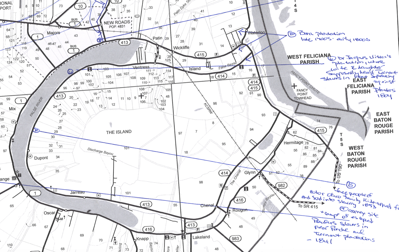
Given these challenges we turned to local knowledge to guide our reconstruction of colonial Pointe Coupee. Historian Brian Costello, the author of several local history books and articles, identified the locations of key historical places on a map. This information serves as a guidepost as we continue to review historical maps that may also locate these named places.
A key breakthrough in our process was facilitated by Julia Lewandoski, a translator on our project, whose PhD research focuses on cartographic histories and land tenure regimes across indigenous territories in eighteenth and nineteenth century North America. Ms. Lewandowski suggested we explore the American State Papers as tool for locating the estates of slave owners in 1795 Pointe Coupee. Costello (2001) also uses this practice to identify and reference the location of lands purchased by Julien Poydras.
The American State Papers (ASP) are a set of thirty-eight physical volumes, contain the legislative and executive documents of Congress during the period 1789 to 1838. Scans of these documents are available on-line from the Library of Congress; the Hathi Trust additionally makes full-text transcriptions available as well.
Two years after the Louisiana Purchase of 1803, an Act of Congress of March 2, 1805, required that all inhabitants of this territory submit a claim to a Board of Commissioners, later referred to as the Old Board, for any land that they had acquired from a British, French or Spanish land grant (Poret, O. 1972. History of Land Titles in the State of Louisiana, Louisiana State Lands office). The land claims from this period for Pointe Coupee can be found in the American State Papers: Public Lands, Volume 2. 1809-1815
Land claims with the ASP are referenced by an OB, or Old Board number, given to the claim by the Board of Commissioners. In the image below, the land claim referenced by OB number 56 is for the estate of Julien Poydras, which was the geographic center of the Pointe Coupe 1795 slave conspiracy.
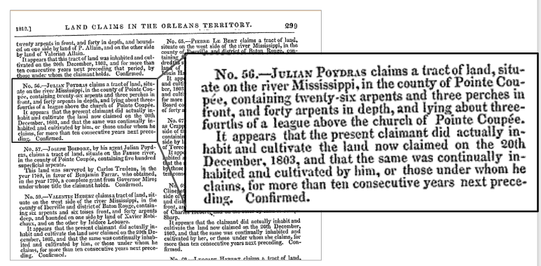
The information in this claim tells us (1) the OB number of the claim, (2) the claimant, here Julian Poydras, (3) the location of the claim, and (4) the area of the tract of land being claimed, (5) that this tract was inhabited by this claimant or by the person from whom this claimant obtained the land for at least ten years prior to December 20, 1803, and (6) that the claim was confirmed. Because of (5) we know that this tract was inhabited at the time of the 1795 Pointe Coupee slave conspiracy. We we assume, lacking any documentation to the contrary, is that this person owned the land in 1795, eight years prior to submitting the claim. This assumption is a source of uncertainty in locating estates that played a role in the 1795 conspiracy, but it is relatively small.
A second component of the Act of Congress of March 2, 1805 required a land survey and subdivision of parcels in the new territory. Maps from these surveys, called historical survey plat maps, contain the results of these surveys and subsequent updates. These maps are available online from the Louisiana Office of State Lands and from the US Bureau of Land Management General Land Office Records website.
The image below shows a plat map of the area within Pointe Coupee that contained the estate of Julien Poydras that is referenced in the ASP as OB 56. This estate is located in the top center of the map, directly below the word RIVER. Each plat map also contains an index that lists the name of owners, identifying numbers, and tract areas.

The key to locating tracts claimed in the ASP on these plat maps is the OB numbers which are listed in both.
|
|
|
|
Tract (section) 14 - Julian Poydras, OB 56 |
Index 14, Julian Poydras, OB 56, 849.12 acres |

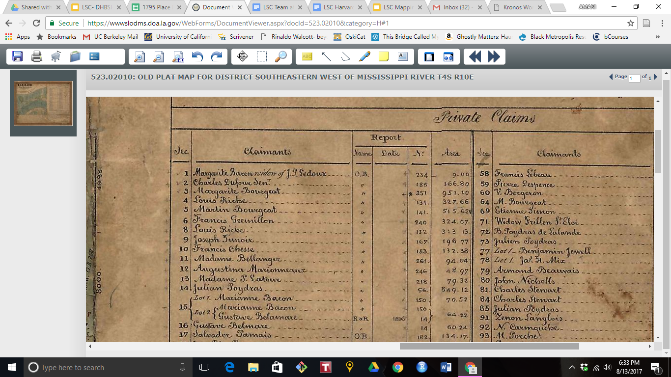
The plat map images shown above are from Survey Plat Map T4S R10E, 1858, LA - Louisiana Meridian, dependent resurvey, date 1858. Although the plat map date is 63 years after the 1795 Pointe Coupee conspiracy, the contents of the map are much older. The OB number cross-referenced to the ASP indicates that this was the location of the Julien Poydras estate. There is however uncertainty in the area of the estate which could differ between the ASP and plat maps as well as the 1795 reality due to either sales or purchases.
Mapping Process
Our process for linking the data in the ASP and survey plat maps was as follows.
ASP Data Processing
-
We downloaded as PDF files pages for Pointe Coupee from the American State Papers: Public Lands, Volume 2. 1809-1815 from the Hathi Trust website.
-
These PDF files were converted to text files (OCR) using Abbyy FineReader (free trial version). We did not use the OCR’d version of the text available on the Hathi Trust website due to the large number of errors contained in these data.
-
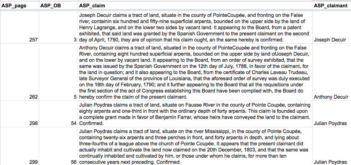
We reviewed and semi-automatically corrected and standardized the OCR text of the ASP pages. See, for example, the image below.
Survey Plat Map Processing
-
We downloaded six plat maps for Pointe Coupee from the BLM website:
-
Survey Plat Map T4S R9E, 1829, LA - Louisiana Meridian, original survey
-
Survey Plat Map T4S R10E, 1858, LA - Louisiana Meridian, dependent resurvey
-
Survey Plat Map T4S R11E, 1858, LA - Louisiana Meridian, dependent resurvey
-
Survey Plat Map T5S R9E, 1842, LA - Louisiana Meridian, original survey
-
Survey Plat Map T5S R10E, 1842, LA - Louisiana Meridian, dependent resurvey
-
Survey Plat Map T5S R11E, 1853, LA - Louisiana Meridian, original survey
-
-
Each plat map was georeferenced using the USGS plat map vector files in order to align it with a geographic coordinate reference system.
-
Each plat map was clipped to remove the non-map components, e.g., the map index.
-
The six plat maps were merged into one map, shown below.

-
The tracts on the plat maps where digitized and assigned a Township - Range - Section number as a unique ID and an OB number if present. This is shown below:
-
Any other data on the map associated with the tract, such as map owner, other owners, id numbers and tract areas, was manually copied into in a spreadsheet.
-
The data from the ASP and the survey plat maps was linked by OB number.
-
We then added a field to the dataset to identify the tracts for estates mentioned in the historical documents of the 1795 conspiracy.
The evolving geospatial data for Pointe Coupee now allows us to create maps like the one shown below as well as explore the data interactively in GIS and web mapping software.
Additional Geographic Data Processing
Not all estates and places noted in the historical documents are listed in the ASP or shown on survey plat maps. The main reasons for this are listed below.
-
Land sales. Slave owners noted in the 1795 conspiracy documents who sold their estates after 1795 but before the Act of Congress of March 2, 1805. For example, the Goudeau estate figured prominently in the 1795 conspiracy but appears to have been sold to Julien Poydras in 1798 (De Ville, 1988, Slaves and Masters of Pointe Coupee, Calendar of Civil Records, 1762-1823).
-
Heirs of slave owners mentioned in the 1795 documents are listed in the ASP or on the survey plat maps. This is a similar problem to (1) but easier to resolve by making assumptions based on genealogical data.
-
Name variants. Names listed in the historical 1795 conspiracy documents don’t match those listed in the ASP or on the survey plat maps. For example we assume that the Santiago Vignes listed in the ASP is the same Jacques Vigne noted in the 1795 conspiracy documents since Santiago is a Spanish variant of Jacques.
-
Common family names. Many estates shown on the survey plat maps share family names listed in the 1795 documents. For example, it’s hard to know if a property listed as being owned by “Madame Jarreau” is the same property owned by the “J. Jarreau” mentioned in the 1795 documents.
-
Missing, incomplete or inaccurate data. Several persons mentioned in the 1795 historical documents are only mentioned by last name, e.g., Patin, Sigur, Nicolet.
A number of sources were used to locate estates or reduce uncertainty in the assumed locations that we have found. These include the references listed here as well as the following:
-
Basic web searches for people and land sales.
-
Dr. Gwendolyn Midlo Hall’s Afro-Louisiana History and Genealogy, 1719-1820 website.
-
Genealogical information available on RootsWeb WorldConnect website.
-
Index of early marriages (cite)
-
De Ville, 1988. Slaves and Masters of Pointe Coupee, Calendar of Civil Records, 1762-1823
-
Costello, B, 2010. A History of Pointe Coupée Parish, Louisiana, The Murray G. LeBeau Memorial Edition. Margaret Media.
-
Thomas, 2009. Pointe Coupee Families in Colonial Louisiana
-
Costello, B. 2001. The Life, Family and Legacy of Julien Poydras. Franklin Press.
-
Tulane University Digital Library (https://digitallibrary.tulane.edu)
In addition, a future phase of archival research in Pointe Coupee, Baton Rouge, and New Orleans will provide additional information from colonial records of the Spanish period. This information will integrated into our geospatial datasets and associated maps.